

Due to its considerable size and rich natural environment, which account for a broad variety of scenery and landscape — from the coastal to the upland areas — Naxos is highly suitable for mountain as well as road biking.
The range of options is wide, from rural roads to exciting trails and specially designed cycling routes in various parts of the island.
Below we set out some of these very interesting routes especially designed for cyclists, but don’t let us preclude your talent for exploration; there are dozens of others waiting for you to discover.
Mountain Biking Naxos: An Intro
Certainly there are not many destinations that can boast a mountain biking route that passes a 6th century ancient temple, medieval fortress, Byzantine church, populated age-old mountain villages as it makes its way through mountains of marble, Cyclopean rock formations, massifs, green valleys, rivers, streams, gorges and roads that circumvent gorgeous blue seas… Welcome to mountain biking on Naxos.
The mountainous terrain of Naxos and its vastly varied countryside is amazing to discover, on foot, by car and by bike.
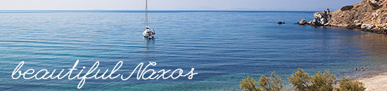
Vast blue-sea vistas are always there in the distance, but head into the heart of the island (at 435 sq km, it is the largest of Cycladic islands) and you are suddenly met with a diverse landscape that changes depending on which direction you are heading.
The coastal zone (91km) offers opens seas; head east for a steep rocky coastline; in between are ravines with plane trees, olive groves and clusters of oak trees to name a few.
An added value to mountain biking on Naxos is the chance to take part in an adventure sport while sightseeing!
Many of the trails include some of the island’s fascinating sites.
These six trails are sure to get you in the mood for mountain biking on Naxos.
A Naxos First: As mountain biking is becoming more and more popular on the island, Naxos held its first Annual Mountain Bike Race in October 2013. The 22.5km (13.9 miles) technically-challenging race, started and terminated at the village of Sagri (11 kilometres from Naxos town) and took participants riders through a scenic route of mountain peaks, blue seas, green valleys and picturesque villages passing sightseeing highlights such as: the magnificent ancient (6th century) Temple of Demetre, villages of Sangri and Damalas and the 16th-century former monastery, Bazeos Tower. The site of the race – in the heart of Naxos’s countryside, known as the Tragea valley – is an area of rare natural beauty that contains some of Greece’s largest collections of Byzantine churches. The route traverses winding natural paths that overlook Agiassos bay and roads at the foothills of Mt. Zas, mythical home of Zeus and the Cyclades’ tallest mountain peak.
Route 1: Wild North (“The King”)
Route: Chora – Eggares – Abram – Apollonas – Messi – Skado – Koronos – Apiranthos – Filoti – Chalki – Galanado – Chora.

This impressive route includes a stretch along the almost uninhabited northeastern coast of the island which ends at the fishing village of Apollonas.
It features a precipitous coastline, with small bays, vineyards and herds of sheep and goats. From Apollonas –famed for its traditional gourmet tavernas- starts a long but not particularly steep uphill track to Koronos, the old, emery miners’ village, which is worth a stroll around.
A short uphill stretch from Koronos to the wind power generators reveals a stunning view of the eastern coast and the upland valleys on the way to Apiranthos.
The use of marble as a building material marks this beautiful mountainous village. It is worth stopping at the four but interesting museums, as well as at the attractive, traditional cafes. Staying on a southbound course and after a short uphill, you begin the long downhill on the slope of Mt. Zas.
After going through Filoti and crossing the big olive grove, you arrive at Chalki –the island’s old capital. Stay on the main road, leaving Sagri village on your left and, after passing through Galanado, you arrive at Chora.
Galanado offers a captivating view of the western coast of the island and Paros.
Route 2: Tragea and the Rocky Arid Zone of Apano Kastro
Route: Chora – Glinado – Vivlos – Sagri – Damarionas – Filoti – Chalki – Potamia – Chora

This picturesque route offers a great first impression of Naxos’s varied landscape. Riding off from Chora, the island’s main town, take a slight uphill in a southeasterly direction.
Once past Glinado, you reach Vivlos, a village offering a superb view towards the island’s west coast, as well as Paros and the fertile plain that stretches south of the main town.
At the edge of the village, a sudden yet brief uphill stage and the ensuing slightly downhill stretch leads to two petrol stations, on the left and right sides of the road. Turning left at the intersection towards Sagri and passing through Apano (Upper) Sagri leads to the main road network.
From this spot, follow the road signs for Chalki, and, two kilometers before the village, turn right for Damarionas, a beautiful village without much tourism activity. Staying on this road leads (on the left hand side) to mountainous Filoti, a village offering a superb view of the Tragea plain and the island’s mountainous massif. Look out for the numerous cafes and taverns along the village’s main road for a small break.
Taking the main road downhill in a northwestern direction leads to Chalki. At the entry point to the village, take a left turn in the direction of Chora at the main intersection and continue cycling until the edge of the village. From here, take a sharp right turn just before the little bridge, pass by the village’s last houses and follow the rural road towards Tsikalario and then Potamia.
This route takes you through the arid, rocky and shaly landscape featuring the remains of the Byzantine Apano (Upper) Kastro at the top of the mountain. Apano Potamia’s refreshing gardens, running waters and taverna by the fountain are ideal for a rest. Carrying on along the asphalt road takes you through Paratrechou valley and back to the main town.
Route 3: A Tour of Two Valleys
Route: Chora – Aggidia – Kato Potamia – Messi Potamia – Pano Potamia – Kalamitsia – Melanes – Aggidia hill – Chora

Ride off from Chora on the eastbound road to Aggidia.
After a short uphill stretch, you enter Papatrechou valley and head for Potamia. Go past a concrete cement production plant and, at the somewhat indiscernible fork towards Agios Mamas, near the waste collection bins, take the downhill on the right in Papatrechou ravine. At least one kilometer on, you arrive at the stream.
Turn left at the cement-paved, slightly uphill road and proceed along and old stone wall.
Turn right at the next crossroads for Kato Potamia. Pass through the village in an easterly direction and follow the old trail –initially uphill and then downhill- to the bank of the stream below Messi Potamia. Staying in the ravine amid the lush vegetation, you come to some stairs and soon reach the old watermill of Pano Potamia.
After a short uphill, go through the village to the small central square and then downhill to the taverna. Its enchanting garden and the excellent quality water from the spring next to it provide a perfect excuse for a break.
Stay on the asphalt road from the parking area in a northwesterly direction to Messi Potamia.
A small, cement-paved road from there leads to Melanes. The route is variedly uphill and downhill.
After passing the highest point, go downhill on the left towards the haunted ruin of the Jesuit monastery at Kalamitsia.
Return on the same dirt road in a northerly direction and as soon as you are past the mountain pass the view of the Melanes valley opens up in front of you. Staying northbound, ride through the narrow alleys of the upper neighborhood of the village, then downhill to the crossroads at the old olive mill and turn left on the main road in the direction of Agios Thalleleos and Chora.
At least 1km on, take a right turn on a cement-paved uphill in a northwesterly direction and you soon have the view of the Eggares valley and the northern coast.
Stay westbound on the initially uphill and winding route to Aggidia. From there, the country road leading to Chora is on the right.
Route 4: Hills, Plains and Beach
Route: Chora (main town) – Kandili – Ypsiloteras monastery – Ammitis bay – Eggares – around Korakias hill – Kourounochori – Aggidia hill – Chora

This is a greatly varied route on the hills around Chora.
The main northern road in the direction of Eggares village climbs along the precipitous coastline, heeding the contours of the area’s small hills.
Once at the point of the new cemetery, exit the main road and turn left onto the secondary road headed in a northwesterly direction, towards the wind turbines. Enjoy the splendid view and start descending towards the fertile plain of Eggares.
Crossing the flat land with the farming plots, the route leads to the northern edge of the plain. Take a right turn here and follow the asphalted road section for a short distance. Before the bridge and almost straight on take the main road and head in an easterly direction until the end of the small valley.
Enjoy the tranquility and relaxation offered by the adjacent stream, dry in the summertime yet rich in foliage. Approximately 700m on, cross to the river’s other side over a low cement bridge and carry your bicycle over the wide uphill stairs for a short distance until reaching a cement-surfaced road.
To the left, towards Messa Gitonia, head up the slanted valley.
Immediately after the water-pumping station, take a sudden right turn onto a rough dirt road that runs past Eggares until reaching the asphalt road connecting Eggares and Melanes.
Turn left at this point in the direction headed for Melanes. Turn right at the cattle farm and ride downhill along the main road headed for Chora, the main town.
Approximately one kilometer after the intersection for Melanes, exit the main road and turn right onto a small cement-surfaced road that leads to a section of the ancient aqueduct.
Continue heading uphill until reaching a point that opens up for a panoramic view of the Eggares plain.
Turn left and head west.
Pass by the antennas on your left and head downhill towards Aggidia and, from there, back to the main town.
Route 5: Villages, Fields, Beaches
Route: Chora – Yria – Vivlos – Sagri – Bazeos Tower – Agiassos – Pyrgaki – Alyko – Kastraki – Mikri Vigla – Orkos – Vivlos – Glinado – Chora

From Chora, head for the archaeological site of Yria through the fields of the plain of Livadi. Entrance is free.
Continue in a southerly direction, pass by the cheese-making facility, leave Agios Arsenios on your right and ascend to the main road.
Traverse Vivlos village, with its old windmills, and continue in a southerly direction to the crossroads for Sagri on the left.
An attractive downhill stretch brings you to the valley of Sagri, with the old monastery of Agios Eleftherios. Outside the village, take a right turn on the main road towards the bay of Agiassos. At the beginning of an 8km downhill is Bazeos Tower, which merits a visit for the good views and the coolness it offers.
At Agiassos enjoy the beach and the view of the Small Cyclades islands, and continue west along the southwestern coast towards Pyrgaki. Follow the dirt road towards Alyko beach –ideal for a swim when northerly winds blow.
Follow the asphalt road on the left and you come to the remains of a huge hotel complex at the tip of Cape Kouroupia. Return on the same road, which has minimal traffic, in a northerly direction.
A detour for the Glyfada salt pan and the long beach is recommended. Two kilometers on, turn left into the road for Mikri Vigla and cross an area with fields to arrive at the beach again.
The route continues through an area with fields, passing by the charming bay of Orkos. At the crossroads for Plaka beach take the uphill road to Vivlos. The majestic view of the coastline compensates for the short but difficult ascent. From Vivlos descend through Glinado to Chora.
Route 6: Bike to the Beaches!
Route: Chora – Agios Georgios – Laguna – Stellida – Agios Prokopios- Agia Anna – Plaka – Orkos – Mikri Vigla – Kastraki – Cape Kouroupa – Alyko – Pyrgaki – Psili Ammos – Glyfada – Kastraki – Mikri Vigla – Orkos – Airport – Chora.
Starting from the port of Chora and heading south, take the coastal road, pass in front of the Town Hall and alongside Agios Georgios beach, a sheltered little bay with calm waters, and continue until you reach Flisvos, a meeting point for surfers from all over the world, as Laguna of Naxos is the ideal spot for this watersport.
Continue on the asphalt road towards Agios Prokopios and turn right at the airport intersection alongside the barrier that separates Laguna from the brackish lagoon.
At this spot the view of the town on the right is exceptional. Continue on this road and at the next junction go straight uphill towards the hill of Stellida, from where you will have another wonderful view of the bay of Chora.
Stay on the asphalt road going southwest, up to the western end of the coast and the church of Agios Prokopios. From here the dirt road between the saltpans and the sand dunes will lead you to the village of Agios Prokopios, a place with hotels and tavernas.
Continue on the coastal road towards the bay of Agia Anna, with its picturesque little harbor and fishing boats.
Continue south until you reach the endless beach of Plaka with its unique sand dunes along its full length.
At the end of the dirt road and moving away from the coast the route goes through an area of cultivated fields, heading towards Orkos and Mikri Vigla.
The beautiful landscape here comprises granite rocks and small romantic bays.
Mikri Vigla, another vast beach with tavernas on the sand, is a well-known meeting point for kite surfing lovers who can be watched in action.
Before you continue straight towards Kastraki, take a break from riding to ascend on foot the rocky hill with the exceptional view of the beach and the island of Paros in the distance. Stay on the asphalt road with spare traffic and continue to Glyfada after Kastraki.
Have a rest here at the taverns of the area, from where you can venture out for a walk in the nearby beautiful and serene – but endangered- juniper forest – a protected area.
Back on your bike, continue on the asphalt road in a southerly direction until you reach the ruins of an enormous abandoned hotel at Cape Kouroupa, viewing the bay of Alyko.
From this point start your return journey, heading north to the crossroads for Kastraki and Mikri Vigla.
Following the same route as in the outbound journey, pass by Orkos and the cultivated fields until you reach the intersection for Plaka.
Turn left, take the new asphalt road and, heading north slightly uphill amid granite blocks, you meet the Agia Anna – Agios Arsenios road at a relatively elevated spot.
Keep straight, going slightly downhill to the north and head back to Chora after passing in front of the airport.
